WATER MUSEUM
1- ÁGUAS LIVRES AQUEDUCT
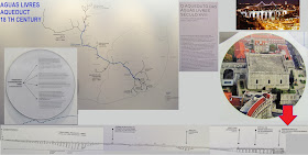
The Águas Livres (Free Waters) Aqueduct was built from 1731 to 1799 by the King’s order. It is a vast system for collecting and transporting water using gravity. It has had National Monument status since 1910 and is considered to be a remarkable work of hydraulics engineering.
This work implied using the water springs of the Águas Livres, integrated in the Sintra mountain range catchment basin, in the Belas region northwest of Lisbon.
In general, the chosen trajectory coincided with that of the old Roman aqueduct. It was only possible to build it through the levy of a tax called the “Water Royal” duty on essential goods such as olive oil, wine and meat.
The system, which withheld the 1755 earthquake, is composed of:
A main section, 14 km long, which starts at Mãe de Água Velha in Belas and ends at the Mãe de Água das Amoreiras reservoir in Lisbon
Several secondary sections to transport water from around 60 sources
Five galleries for supplying around 30 fountains in the capital city
In total, the Águas Livres Aqueduct system, inside and outside of Lisbon, was about 58 km long in the mid-19th century. Its waters were no longer used for human consumption as of the 1960’s.
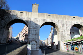
The extraordinary arches of the Alcântara valley, which cover a length of 941 metres, correspond to 35 arches in all, including the largest stone arch of this type in the world at 65.29 m high and 28.86 m wide.
The Water Museum promotes and conducts free and guided tours of the arches in the Alcântara valley.

The Águas Livres Aqueduct , "Aqueduct of the Free Waters") is a historic aqueduct in the city of Lisbon, Portugal. It is one of the most remarkable examples of 18th-century Portuguese engineering. The main course of the aqueduct covers 18 km, but the whole network of canals extends through nearly 58 km.
The city of Lisbon has always suffered from the lack of drinking water, and King John V decided to build an aqueduct to bring water from sources in the parish of Caneças, in the modern municipality of Odivelas. The project was paid for by a special sales tax on beef, olive oil, wine, and other products
The Aqueduct is one of the largest engineering works built in Portugal, and that had the greatest impact in the modern history of the country, establishing itself on the stretch of the river Alcantara (universally considered a masterpiece of architecture and engineering of the century XVIII), or the Mother of Water, in Amoreiras as unmistakable hallmarks of Lisbon. Yet this immense work of supplying the capital was greatly due to the areas bordering the North, where he held several water intakes. The conduit dispersed into five municipalities current, developing along more than 18 Km
Its construction was given by royal charter of 1731
ÁGUAS LIVRES AQUEDUCT
Address | Calçada da Quintinha 6, 1070-225 Lisbon
GPS: 38º43’47.09”N 9º10’13.55”W
GPS: 38º43’47.09”N 9º10’13.55”W
| Bus: 742, 751, 758 |
TO TAKE PICTURES, BEST AFTERNOON
PHOTOS TAKEN ALONG THE VIADUCT FACADE.
TO GET THERE:
THE BEST WAY TO GET THERE IS WALKING
BY BUS: take bus 702, AT Praça Marquês de Pombal and get off early in the Calçada dos Mestres.
2 - MÃE D'ÁGUA (AMOREIRAS)
FINAL PART OF THE AQUEDUCT. MOTHER OF WATER ( MÃE D'ÁGUA) - RUA DAS AMOREIRAS.
GPS N38.72159 ; W9.15605
MÃE D’ÁGUA DAS AMOREIRAS RESERVOIR
Address | Praça das Amoreiras 10, 1250-020 Lisbon
GPS: 38º43’15,64”N 9º9’20,12”W
 |
| AQUEDUCT ENTRANCE |
THE BEST WAY TO GET THERE IS WALKING
BY BUS: take bus 702, AT Praça Marquês de Pombal and get off early in the Calçada dos Mestres.
2 - MÃE D'ÁGUA (AMOREIRAS)
FINAL PART OF THE AQUEDUCT. MOTHER OF WATER ( MÃE D'ÁGUA) - RUA DAS AMOREIRAS.
GPS N38.72159 ; W9.15605
MÃE D’ÁGUA DAS AMOREIRAS RESERVOIR
Address | Praça das Amoreiras 10, 1250-020 Lisbon
GPS: 38º43’15,64”N 9º9’20,12”W
| Bus: 706, 709, 711, 727, 738, 758 | Subway: Rato
http://www.epal.pt/EPAL/en/menu/water-museum/useful-information
A
 |
| LISBON - MUSEUM OF WATER - MÃE D'ÁGUA OPEN EVERY DAY - 10 A.M. TO 6 P.M. CLOSED - SUNDAY GPS N38.72159 ; W9.15605 |
LISBON SEEN FROM THE TERRACE OF MÃE D'ÁGUA
B - AMAZING TILES
C- CHURCH
D
E - GARDEN
After visiting the aqueduct, climb the Calçada da Quintinha and turn right. Take the Calçada dos Mestres. Go straight ahead until the end of Rua Professor Sousa Cãmara. At the shopping center AMOREIRAS, turn left and go down the RUA DAS AMOREIRAS.
 |
| LISBON-SHOPPING CENTER AMOREIRAS |

 |
| LARGO DO RATO - CHAFARIZ gps N38.72000 ; W9.15405 |
3 - PATRIARCAL RESERVOIR
GPS N 38.71614 ; W 9.14888
PATRIARCAL RESERVOIR
Address | Praça do Príncipe Real, 1250-184 LisbonGPS: 38º42’ 59,89” N 9º8’ 54,68” W
Bus: 758, 773 | Subway: Rato
http://www.epal.pt/EPAL/en/menu/water-museum/useful-information
4 - ESTAÇÃO ELEVATÓRIA DOS BARBADINHOS -
( THE BARBADINHOS STEAM PUMPING STATION )
BARBADINHOS STEAM PUMPING STATION
PERMANENT COLLECTION
Address | Rua do Alviela 12, 1170-012 LisbonGPS: 38º 43’ 8,66” N 9º7’ 9,47” W |
Bus: 735, 794,706, 712, 782 (Santa Apolónia)
Train Station: Santa Apolónia | Subway: Santa Apolónia
Group booking | tel. +351 218 100 215 | museu.epal@adp.pt | www.epal.pt
Train Station: Santa Apolónia | Subway: Santa Apolónia
Group booking | tel. +351 218 100 215 | museu.epal@adp.pt | www.epal.pt
http://www.epal.pt/EPAL/en/menu/water-museum/useful-information
The Museu da Água (Water Museum) is located in Lisbon, Portugal.
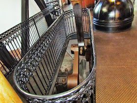
The museum, the former steam pumping station of Barbadinhos, Lisbon, built in 1880, is in a 19th-century industrial building. The museum features four large steam engines dating from 1880. One has been reconditioned as a working demonstration. The pumps were in use until 1928. The museum also features portions of Lisbon's 1746aqueduct.
In 1990 the museum was awarded the Council of Europe Museum Prize
The water carried by the Águas Livres Aqueduct, from Lisbon, was conducted through an emissary network that consisted of five galleries, mostly underground, with about 12 kilometers long, whose job was to ensure the supply of water to fountains and some public establishments: Campo Santana, Necessidades, Loreto, Esperança and Rato. The Loreto Gallery, built in 1746, stands out with its route currently open to visitors between the Casa do Registo in Rua das Amoreiras, the Patriarchal Reservoir, Rua do Século and the Mirador of São Pedro de Alcântara.
 |
| AMADORA |
There is a pedestrian route, in the Serra de Monsanto, which follows the route of the aqueduct, as shown in the pictures that follow. If the flow of visitors to visit the aqueduct permitting, it might be possible to ask the guard to open the door at the end of visitable part of the aqueduct. Could do pedestrian route, see the scenery from an old mill and at "Sítio do Calhau", down to the Marquês de Fronteira Palace (beautiful tile panels - at the moment, I do not know the timing of visits). Then continue down, pass a pedestrian overpass (over railroad tracks) and straight ahead could get to the ZOO and the Metro station " JARDIM ZOOLÓGICO"
GPS N38.73378 ; W 9.17260 -








.JPG)






.jpg)


